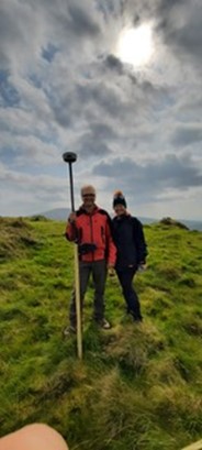
Between 23 August and 4 September, a three person team comprised of Cherie Edwards, her primary supervisor Dr. Drik Brandherm (Queen’s University Belfast) and Research Fellow Dr. Linda Boutoille undertook an excavation of three 1.5m x 1.5m test trenches at the summit and on the middle slope of Brusselstown Ring in Co. Wicklow, Ireland. The goal was to confirm whether or not the test trenches were located on anthropogenically altered sites and to obtaining samples for radiocarbon processing. Unfortunately an integral member of the team responsible for the siting layout of the test trench, Dr. James O’Driscoll, was unable to join us.
Brusselstown Ring is located in County Wicklow in the townland of Spinans Middle, Brusselstown and Castlequarter, on a southwest spur of the Wicklow Mountains. It is one of nine hillforts in the immediate area that comprise the Baltinglass Hillfort cluster. The mountain range constitutes one of the largest contiguous unbroken areas of high-altitude landscape in Ireland, with more than 500 km2 of the landscape having an elevation in excess of 300m OD.
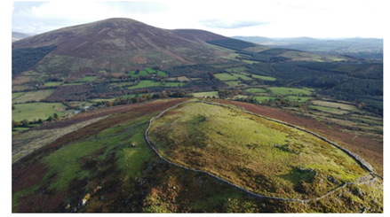
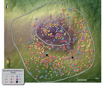
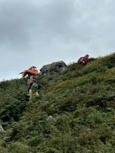
Brusselstown Ring sits at 409m OD, occupying a relatively flat summit within an area of gradual slope (Fig 1). A GPS and photogrammetry survey by Dr. James O’Driscoll in 2017 produced evidence identifying in excess of 600 dwellings at the summit of Brusselstown Ring, within the uppermost and middle enclosing elements of the site (Fig 2). The area is currently dominated by scrub and bracken and marked by outcroppings of large rock, with some lower slopes currently planted in conifer for forestry. However, the forestry area has not encroached into the enclosed areas of the summit of the Brusselstown Ring itself, leaving it devoid of forestry damage. In the valleys on the south, east and west there are watercourses of varying degree. To the northeast it overlooks the Glen of Imaal. Brusselstown Ring itself has extensive panoramic views over the countryside surrounding it, with some restricted view on the northern side.
The innermost enclosure (top of the summit) is encircled by a stone wall along the 370m contour line, and encloses 4.63ha of a naturally oval shaped terrace. The stone wall (bank) is 5.3–11.7m wide (average 9.5m) and up to 1.2m high, and of drift geological stone. A downslope spread of scattered stone suggests that the wall once stood higher. The secondary enclosing element lies 124–305m outside the inner wall mirrors the circular layout around the innermost wall without concern for the natural contours. Spinan’s Hill complex is the largest hillfort in Ireland.
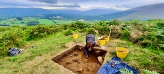
At the start of our excavation the area had no dating and the status of the anomalies identified as house platforms remained uncorroborated. Without digging we were unable to answer the question as to whether or not the site falls within the timeframe in which there is a fall-off in the dates associated with occupation on non-hilltop sites in Ireland. Trench1 and Trench 2 were successfully opened during some lovely late summer weather, and both produced evidence consistent with prehistoric modifications by humans. Trench 1 indicated the occurrence of a burning event and a v-shaped trench cut into the underlying geologic layer. Trench 2 contained a large sloping pit that had two layers of charcoal laden infill, and one confirmed posthole (with three additional postholes inferred). Both trenches produced ample quantities of charcoal from which numerous samples were retained for radiocarbon testing. Trench 2 also produced at least one prehistoric lithic object.
The samples taken from Brusselstown Ring will now go through the process of export to Queen’s University Belfast, species identification for charcoal samples and submission for radiocarbon processing. While it will be some time (12-16 weeks) before dating is returned, one thing can be certain of the outcome from the excavation: the presence of anthropogenic modifications has been confirmed within the enclosing elements of Brusselstown Ring. While more work will be needed to confirm that this pattern holds at other anomalies identified by Dr. O’Driscoll’s photogrammetry, there appears at present to be validity to the premise that the site formed one of the largest prehistoric nucleated settlements in Ireland.
A special thank you to UKRI and NERC for providing funding for the excavation through QUADRAT.